Share on Facebook
 Share on X
 Share by Email
 Share on Google Classroom
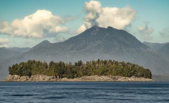
British Columbia is Canada's most westerly province, and is a mountainous area whose population is mainly clustered in its southwestern corner. BC is Canada’s third-largest province after Québec and Ontario, making up 10 per cent of Canada’s land surface. British Columbia is a land of diversity and contrast within small areas. Coastal landscapes, characterized by high, snow-covered mountains rising above narrow fjords and inlets, contrast with the broad forested upland of the central interior and the plains of the northeast. The intense "Britishness" of earlier times is referred to in the province's name, which originated with Queen Victoria and was officially proclaimed in 1858.
Geography

British Columbia is divided by two of Canada’s seven physiographic regions. These regions are the Cordillera and the Interior Plains. The vast majority of the province is in the Cordillera region, while the northeast corner is part of the Interior Plains.
The Cordillera is part of a mountain system that extends the length of the western third of North and South America. The Cordillera mountain system covers most of British Columbia. It consists of two main mountain ranges. These ranges are the Coast Mountains in the west and the Rocky Mountains in the east. Other significant mountain ranges in British Columbia’s Cordillera region are the Columbia Mountains and the Cassiar-Omineca Mountains. Both ranges are west of the Rocky Mountains. The Columbia Mountains are in the province’s south-east corner while the Cassiar-Omineca Mountains are in the north.
The coniferous trees of coastal British Columbia are the tallest and broadest trees in Canada. Douglas fir, western cedar, balsam fir, hemlock and Sitka spruce grow very well in the mild, wet climate. They are the basis for the province’s forestry industry. Similar trees, plus lodgepole pine, ponderosa pine and aspen, grow on the middle slopes of the interior mountains and plateaus. In contrast, the Coast Mountains and the lower river valleys across the southern third of the province have a drier climate. The drier climate creates grassland in these regions.
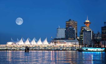
Vancouver’s metropolitan area is home to over 50 per cent of the province’s population. Vancouver, and the communities that surround it, are British Columbia’s commercial, cultural and industrial centre. A slightly broader region, sometimes called the Georgia Strait region, includes Victoria and the southeast coast of Vancouver Island. (See also Geography of British Columbia.)
People
Urban Centres
The province’s population has always lived primarily in cities, and in 2021, 89.5 per cent of the population was classified as urban, most in the southwest region.
Metropolitan Vancouver is the largest city in the province. There are three additional metropolitan areas: Abbotsford-Mission, Kelowna and Victoria, the capital. Mid-sized cities include Prince George, Kamloops, Chilliwack and Nanaimo, while smaller communities include Cranbrook, Penticton, Vernon, Dawson Creek, Prince Rupert, Courtenay, Port Alberni, Fort St. John, Terrace and Williams Lake.
Labour Force
In 2021, the sectors employing the most British Columbians were health care and social assistance, retail, and professional, scientific and technical services. The unemployment rate was 8.4 per cent.
Language and Ethnicity
Similar to other provinces, the top ethnic origins reported in the 2021 Census reflected European roots (the top three were English, Scottish and Irish). Where BC’s ethnic make-up differs, however, is in the large proportion of visible minorities — just over 34 per cent in 2021, one of the highest percentages in the country.
Of the visible minority population in BC, the largest communities were Chinese and South Asian. There is also a relatively significant Indigenous population (5.9 per cent in 2021).
The province’s present-day ethnic make-up is a reflection of its history. In the early part of the 20th century more than 75 per cent of the province’s residents were of British origin and most of the population spoke English as their first language. In the mid-19th century Chinese people began working in the mines of the Cariboo, and in the early 1880s many more Chinese were brought to BC as labourers for the building of the Canadian Pacific Railway (CPR). Afterwards many of them settled in Vancouver, and a smaller "Chinatown" also arose in Victoria. Japanese Canadians also settled in southwestern BC between 1900 and 1940.
As in other parts of Canada, the percentage of people of British origin has declined rapidly since 1950. Large numbers of East, Southeast and South Asians began immigrating to BC in the 1970s.
The earlier part of the province's history was marred by racism, particularly the anti-Asiatic riots of 1907 and theKomagata Maru incident of 1914. Stirred up by politicians of all parties, fears were rampant that British Columbia's future as a "white province" was threatened. The population of Japanese and Chinese was less than 40,000 in 1921, but their concentration in the Lower Mainland and southern Vancouver Island, combined with the restricted forms of employment available to them, made them conspicuous.
Because they were hard-working and forced to take lower wages the Japanese and Chinese population was considered unfair competition by the unions and the agricultural community. The campaign of the Asiatic Exclusion League (established 1921) and others resulted in the Chinese Immigration Act of 1923, which effectively ended Chinese immigration.
Many Japanese were evicted from their coastal fishing villages during the Second World War and placed in internment camps. Political discrimination against non-whites in BC finally ended after the Second World War when the Chinese and Hindu populations were enfranchised in 1947, and the Japanese in 1949.
Religion
Since the near majority of people in BC have some British background and are English-speaking, as in other parts of Canada, they are predominantly Christian(about 34.2 per cent according to the 2021 census). Those claiming no religious affiliation numbered just over 52.1 per cent.
History
Aboriginal Peoples
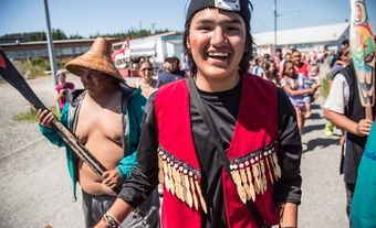
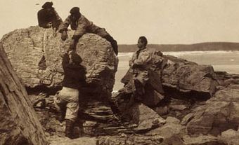
The coasts and interior valleys of British Columbia were first occupied sometime after the last Ice Age. Occupation of some sites in BC has been confirmed by carbon dating at about 6,000–8,000 years ago. The people of the Northwest Coast lived in autonomous villages of 200 to 1,000 people and had access to a particularly bountiful environment that provided abundant shellfish, salmon and even whales. Groups living along the coast used a variety of fishing tools and techniques, and used forest resources to build large and sophisticated plank houses. The coastal people concentrated along the lower reaches of the major salmon rivers. These groups developed an elaborate culture typified by totem poles and the potlatch (see Tagish; Tsimshian; Haida; Tlingit; Kwakiutl; Nootka; and Native People: Northwest Coast). The interior inhabitants, such as the Carrier, Interior Salish and Kootenay were generally nomadic and depended on hunting. Those groups living in the Subarctic region of the interior generally fished and hunted moose and caribou, while those living in the southern interior had a milder climate. The availability of salmon made it possible for the groups living in the southern interior to winter in small villages.
European Settlement
Due to its distance from the eastern coast of Canada and the barrier to east-west movement created by the mountains, the Pacific Northwest was very difficult for early Europeans to reach and was the last part of North America they explored. The first permanent European settlement came with the development of the fur trade in the early 19th century. A flurry of activity followed the discovery of gold on the lower and middle Fraser River (see Fraser River Gold Rush), resulting in an inland system of supply and transportation along the Fraser River to the Cariboo Mountains. By the 1880s more permanent mining towns began to dot the valleys of the southeast – each supported by local forestry, small farms and complex rail, road and water transport. In contrast, on the southwest coast settlement was more urban and commercial.
From 1860 to 1890 Victoria, the capital, was the main administrative and commercial settlement, and the supply centre for interior and coastal resource development. Vancouver, on Burrard Inlet north of the mouth of the Fraser River, was selected as the site for the western terminal of the CPR in 1886. Vancouver soon replaced Victoria as the commercial centre and became the main port for both coastal and interior products to move to world markets.
Overall, British Columbia developed contrasting coastal and interior settlement patterns which remained the same throughout the 20th century, although densities increased. The population has always been primarily urban, living in the southwest region. The remaining population is dispersed across the southern half of the province, mainly occupying the north-south valleys or resource-based settlements along the main transportation lines. The only major farming populations live in the Okanagan Valley and dispersed along the highway between Kamloops and Prince George. These linear population clusters are separated from each other by unoccupied mountain ranges. With the exception of an urban and agricultural cluster in the Peace River area of the northeast, few people live north of Prince George and Prince Rupert.
Europeans arrived at the northwest coast much later than they did other areas of the continent. Spaniards under Juan Pérez Hernández were probably the first Europeans to see the coast of BC in 1774. They did not land, but Pérez claimed the region for Spain. Four years later James Cook took his two British ships into Nootka Sound on the west coast of Vancouver Island. Within a few years British traders came by sea and developed a flourishing fur trade with coastal Aboriginal peoples.
The Spanish had established a trading post at Nootka Sound and seized British ships there, and in 1789 Spain and Britain had a dispute over the ownership of West Coast North America. This Nootka Sound Controversy was settled by the Nootka Conventions of 1790–94, which did not determine ownership, but gave equal trading rights to both countries.
British claims were strengthened after 1792 when ships under George Vancouver carried out a careful three-year mapping of the coast from Oregon to Alaska. Vancouver named many of the bays, inlets and coastal landform features. In this period of worldwide European colonialism, there was no concern among European governments and businessmen that this area was already occupied by Aboriginal peoples.
In 1793 the first European report about the interior of BC was made by the North West Company fur trader Alexander Mackenzie. He entered the region from the east via the Peace and Upper Fraser rivers, and explored westward across the Chilcotin Plateau and through the Coast Mountains to the long inlet at Bella Coola.
Two other members of the North West Company, Simon Fraser and David Thompson, explored other parts of the interior early in the 19th century. They established the first permanent European settlements in the province, which were fur trade posts supplied from Montréal. In 1808 Fraser reached the mouth of the river which now bears his name, and in 1811Thompson found the mouth of the Columbia River after exploring the river routes of southeastern BC.
For about 50 years, while eastern North America was being occupied and settled by European agricultural people and dotted with commercial cities, the mountainous western part of the continent remained little-known territory on the fringes of fur-trade empires controlled from eastern cities.
During the first half of the 19th century the British-owned Hudson’s Bay Company controlled the western fur trade, including the area of present-day Washington and Oregon. In the 1830s American settlers began to move into the southern part of this region, and refused to recognize the authority of the British company.
Conflicting territorial claims were settled in the 1846 Oregon Treaty, which established the southern boundary of BC along the 49th parallel, with the exception of Vancouver Island. In anticipation of this result the HBC had moved its headquarters to newly-established Fort Victoria in 1843.
In 1849 the British government granted Vancouver Island to the HBC for colonization, and in 1851 James Douglas, an official of the company, became governor of the new colony. In 1856 Douglas established a legislative assembly for Vancouver Island. At mid-century the only non-Aboriginal settlements within the boundaries of present-day British Columbia were fur trade posts on the coast, such as Victoria, Nanaimo and Fort Langley, and in the interior, such as Kamloops, Fort (later Prince) George and Fort St. James.
Development
This relatively quiet period of history ended in 1858 when gold was discovered in the sand bars along the Lower Fraser River. The ensuing gold rushes brought thousands of fortune hunters from many parts of the world, but mainly from the California goldfields. Many fortune hunters came by boat from San Francisco, crowding into inadequate facilities in Victoria to buy supplies and receive permits.
Prospecting took place upstream along the banks and bars of the Fraser River during 1858. The town of Yale was established as a trans-shipping centre at the south end of Fraser Canyon, and as the eastern end of water transport from the Fraser River mouth. Gold seekers walked the tributaries of the Fraser River and major gold finds were made east of Quesnel.
The boomtown of Barkerville arose at the western edge of the Cariboo Mountains as the chief service town for the Cariboo goldfields. At its peak in the early 1860s Barkerville likely held a fluctuating population of about 10,000, making it the largest settlement in western Canada at that time.


In order to establish government and maintain law and order around the goldfields, the British established a separate mainland colony of British Columbia in 1858 under the authority of James Douglas, who also remained the governor of Vancouver Island. The new settlement of New Westminster, located slightly inland on the north bank of the Fraser River delta, was proclaimed capital of the new colony in 1859 and controlled river traffic entering the Fraser River en route to the interior. In the early 1860s the amazing feat of building the Cariboo Road along the walls of the Fraser Canyon was accomplished in order to move supplies to interior settlements.
In 1866, with gold production declining and people leaving, the British government united the two colonies to reduce administrative costs. New Westminster was the capital of the combined colony for two years before protests from the older capital, Victoria, resulted in the seat of government being moved there in 1868. The resulting physical separation of the capital from the majority of the people and economic activity on the mainland later led to communication problems for the region, and many government services and offices had to be duplicated on the mainland.
After 1867 the British colony on the West Coast debated whether it should join the new Confederation of eastern provinces known as Canada. In 1871 the 12,000 non-Aboriginal residents of BC agreed to enter the Dominion of Canada on the condition that the federal government build a transcontinental railway to link it with the eastern provinces. The federal government agreed, but the new province waited, rather impatiently at times, for 15 years before the Canadian Pacific Railway reached the southwest coast. (See also British Columbia and Confederation.)
The union with Canada was an unhappy one at first. The new province ran heavily into debt; the cost of governing a large mountainous area with few people was very high, and revenues from resource users were low. More than one-third of the province's white residents lived in or near Victoria. Even by 1881 the white population of 24,000 was less than the estimated 25,000 Aboriginal peoples.
The hoped-for expansion of trade with East Asia did not develop immediately with the completion of the Canadian Pacific Railway in 1885. However, the railway did bring people to the port of Vancouver and by 1901 that city had surpassed Victoria in population. Vancouver's population of almost 27,010 in 1901 had been reached within 15 years, whereas after 58 years of occupation Victoria had only 23,688 people.
Around the turn of the 20th century entrepreneurs came to British Columbia to exploit the province's vast resources. A salmon-cannery industry was established along the coast. There were sawmills all around the shores of Georgia Strait and particularly along eastern Vancouver Island, and the first pulp and paper mill was completed at Powell River in 1912.
The major expansion of the forest industry came, however, after the First World War when the Panama Canal opened and gave access to markets around the north Atlantic region. Since access to capital and natural resources for export was more important than ownership of farmland, BC attracted a different type of settler from those who settled on the land on the Prairies and across eastern Canada.
In interior BC in the 1890s the major resource development and settlement centred on the mining activity in the Kootenay region of the southeast. Prospectors, mainly from mining camps in western Montana and Idaho, moved northward along the valleys and discovered gold and base metals in the area west of Kootenay Lake. Mining camps sprung up in the Slocan Valley, at Rossland, near Grand Forks and elsewhere. Nelson became the main service, supply and administrative centre, with a population of about 4,500 in 1911.
Railways extended northward into the interior from the US, and the CPR built a line westward through the Crowsnest Pass in 1899 to bring coal from Fernie to smelters in the mining centres. By about 1914, however, many of the mines had closed and some towns were abandoned, although other mines opened in later years. The extension of the Kettle Valley branch of the CPR to the coast during the First World War came after the peak of mining activity in the Kootenay region.
Agriculture brought settlers to the south-central interior. At the time of the early 1860s Cariboo Gold Rush ranching was established in the grassland valleys and rolling basins across the southern interior plateau. Irrigation was developed west of Kamloops and in the northern Okanagan Valley early in the 20th century. Irrigation for orchards that spread south from Vernon aided settlement projects for returning soldiers after the First World War (see Veterans’ Land Act).
The Grand Trunk Pacific Railway west from Edmonton through the Upper Fraser, Bulkley and Skeena valleys was built in 1907–14 and was intended to give Canada a second gateway through the mountains to the Pacific coast. After the railway was built Prince George became a minor sawmill centre, with rail access eastward to the growing housing market in the Prairie provinces. However, the port and rail terminal at Prince Rupert never developed the anticipated volume of traffic, partly because there was little need for incoming freight. Despite its hopes, the small town remained mainly a fisheries centre.
International political upheaval during 1930–45 and the resulting loss of world markets led to a serious economic decline in BC’s resource-based activities. After about 1950, however, the improved transportation system did much to integrate the interior resource economies and settlements with coastal collection, processing and management centres.
Appropriately, the theme of Expo 86, held in Vancouver, was transportation and communications. Thousands of Canadians migrated to BC, attracted by the mild climate and perceived economic opportunities, joining thousands of other immigrants from Asia. These people not only provided labour and management for the growing commercial and service occupations, they were also consumers of goods, services and entertainment. In the 21st century, BC is one of Canada's most prosperous and fastest-growing provinces.
Economy
Resource-based activities have been the basis of BC's economy throughout its modern history. Aboriginal people depended on the resources of land and sea for their food, clothing and exchange. The first items of trade desired by Europeans were sea otter pelts from the coast and animal furs from the interior.
Europeans were primarily attracted by mineral resources, notably gold in the central interior and southeast, and also by coal on Vancouver Island, near Nanaimo and Cumberland. By the 1880s the tall, straight coniferous trees of the coast forest were being cut for lumber to supply other Pacific Rim settlements, and salmon were being canned at numerous river-mouth canneries to be shipped throughout the world.
In the 19th century BC’s natural resources supplied markets elsewhere in Anglo-America or in East Asia, or Europe. Local manufacturing consisted primarily of some first-stage processing of these resources.
As population increased in the 20th century and concentrated in or near the ports of the southwest, consumer-goods manufacturing began in the southwestern cities. This was aided by the high cost of transporting manufactured goods from eastern Canada and the US, and by an ample supply of hydroelectric power. Agricultural settlement expanded across the lowland and delta of the Lower Fraser River. The management and financial activities related to resource development remained in the coastal cities, mainly Vancouver.
Agriculture
While only 3 per cent of BC’s land area is used for agriculture, the province is well-known for its fruit crop, leading the country in the production of berries, wine-grapes, fruits and nuts. Farm cash receipts totalled $2.9 billion in 2014 (farm cash receipts are Statistics Canada’s way of measuring the agriculture sector’s contribution to the country’s gross domestic product, on a province-by-province basis). Important crops include grapes, blueberries, cherries, raspberries, pears and apricots. Farming in BC had its origins in supplying the mid-19th century trading posts. The growing cities of Vancouver and Victoria stimulated agricultural expansion in the Fraser Valley and on Vancouver Island. In the 1890s fruit and vegetable growing were established in the Okanagan and beef ranching in the Cariboo region.
The largest area of cultivated land in BC is in the Peace River area, which accounts for about 90 per cent of the province’s grain harvest. The small farms of the Lower Fraser River have the longest frost-free season in Canada and produce dairy and livestock products, vegetables, small fruits, and specialty crops such as blueberries, cranberries and flower bulbs. In the dry southern interior, agriculture flourishes only where irrigation systems have been established.
The narrow benches and terraces above Lake Okanagan are one of Canada's three main fruit-growing regions and an important grape-growing area. The small, intensive farms produce apples, pears, peaches, cherries, plums, grapes and apricots. There are cattle ranches across small areas of grassland on the southern Interior Plateau, but not enough meat is produced to supply even the Vancouver market.
Despite the scarcity of high-quality agricultural land in BC, in the period from 1966–71 urban sprawl was consuming over 6,000 hectare of prime agricultural land per year. About 20 per cent of the prime agricultural land of the Lower Fraser and 30 per cent of the Okanagan had already been converted when in 1973 the Land Commission Act froze the disposition of agricultural land for non-agricultural use, despite the great demand of it for housing, industry, hobby farms and country estates.
Forestry
Forestry was the main component of BC's economy throughout the 20th century and continues to play an important role in the 21st century. Employment in this sector has declined over the past several years due to a variety factors, including the collapse of the US housing market after the 2008 financial crisis and the negative impact of the mountain pine beetle on interior forests. Exports of newsprint have been particularly affected by the growing popularity of online news sources and have declined by 80 per cent in the last two decades. However, forest products are still the province’s largest export commodity.

Commercial logging began in the 1840s on Vancouver Island and spread with the Fraser River Gold Rush of 1858. After the middle of the 19th century lumber mills were established in the southwest to supply the building needs of growing settlements and to export to nearby Pacific settlements. Temporary sawmills also operated near all of the scattered mining communities in the interior; some of these mills, located on the two main railway lines, were able to export lumber eastward to the growing Prairie towns in the early 20th century.

Lumber production expanded rapidly along the coast after the First World War, as the newly opened Panama Canal made eastern US and European markets more accessible to West Coast mills. Most lumber companies extended their logging camps northward along the coast and transported the logs by water to large sawmills around the Georgia Strait region. With minor exceptions, such as near Prince Rupert, this pattern of north coast primary cutting and south coast processing and export has been maintained.
Pulp and paper mills were established at a few places around the Strait of Georgia early in the 20th century, but these mills did not have large markets for newsprint and paper similar to the markets in the eastern US available to eastern Canadian mills. Unlike eastern mills, the pulp and paper mills of BC became integrated into existing sawmill operations and received much of their wood fibre raw material from product residue, such as sawdust and chips from adjoining lumber mills.
The pulp and paper industry remained coastal until the mid-1960s, when mills were opened in several places across the interior. This interior expansion was part of the general spread of the forest industry into the interior of the province stimulated by increased foreign markets, improved interior road and rail transport, new government concessions and cutting rights to forested areas, and a concern for possible depletion of the coast’s forest reserves.
Throughout the 1970s the interior produced about half of the value of provincial forest products. Early in the 20th century small sawmills disappeared along the coast, and after 1950 interior small sawmills also disappeared. These were replaced by large centrally located sawmills, sometimes with adjoining pulp and paper or paper mills.
Although water transport, often in self-dumping log barges, is still the chief means of transporting logs to the mills along the coast, water transport is rarely used in the interior — unlike the river-based log transport system which evolved in eastern Canada. Interior logs and finished forest products are all moved by road or rail and therefore all forestry-based settlements are located on the main railways or highways.
In 1986–87 the BC legislature passed three new acts dealing with the responsibilities of the Ministry of Forests in managing, protecting and conserving forest resources. Pressures on the industry increase as demands grow for preservation of the forests for recreation, wildlife, aesthetics, and as a resource for future generations. In the mid-1980s the industry, after dramatically increasing its penetration of the US market, was under pressure from US producers for alleged unfair competition (see Softwood Lumber Dispute). This dispute led to years of bitter negotiations and significant reductions in lumber exports to the US (see also Forest and; Forest Economics).
In the late 1980s the forestry sector came under increasing criticism for its forestry practices and the harvesting of old growth forests. Preservationists won some victories (Carmanah Valley and Clayoquot Sound) after initiating national and international campaigns. Through the Forest Reserve Act (1994) the provincial government is trying to prevent similar future confrontations by securing a commercial forest land base. In 2007 the government announced the Coastal Forest Action Plan, aimed at improving the sector’s competitiveness and encouraging a shift to harvesting second-growth trees.
Mining
Mining has a long history in British Columbia, and remains an integral piece of the province’s economy. Coal, copper and molybdenum make up the bulk of the materials mined. Gold, silver, lead and zinc are also of significance.

Mining became important in BC in 1858 with the Fraser Gold Rush and later discoveries in the Cariboo region. Between 1890 and 1910 the Kootenay region of southeastern BC became one of the most important mining areas of Canada. The huge smelter-refinery at Trail receives ore from BC, the Yukon and the Northwest Territories.
Coal was first mined near Port McNeill and soon after at Nanaimo on Vancouver Island in the mid-19th century. Immense coal deposits in the Fernie-Crowsnest Pass area were used by the Trail smelter and by the railways until both converted to diesel fuel. Both metallurgical and thermal coal is exported from southeastern BC to Japan and elsewhere. The younger sedimentary rocks of northeastern BC, like those of the interior plains of Alberta, are sources of coal, petroleum and natural gas. The latter two products are transported by pipelines to urban markets in southwestern BC and the adjoining northwestern states of the US.
Throughout the 20th century metal mines have opened and closed across the southern interior from Grand Forks to Princeton. In the early 1980s mining in the area was highlighted by large, open-pit copper mines southwest of Kamloops. Other metal mines across the Interior Plateau from near Williams Lake to Babine Lake in the northwest have produced intermittently.
Mines have also operated intermittently along the coast of BC for more than a century. Base-metal mines opened and closed near Stewart, northeast of Prince Rupert, and at several places on Vancouver Island. Iron ore and copper, to name just two examples, have been exported to Japan from coastal mines. Because nearly all of BC’s mineral production is consumed outside of the province, the fortunes of the mining industry are largely determined outside of the province’s boundaries.
Energy
British Columbia produces a surplus of energy in the form of electrical power, coal, petroleum and natural gas. Of these, two are of particular importance: BC is one of the largest natural gas producers in the country; and hydroelectricity is the province’s largest source of electrical power generation. BC Hydro, a Crown corporation, is one of largest electric utilities in Canada. The British Columbia Transmission Corporation is also a Crown corporation, with the mandate to plan, build and operate BC Hydro’s electrical transmission system. In addition to these Crown corporations the province also has several private utilities companies, such as FortisBC, which owns transmission and distribution lines that connect with BC Hydro. There are also a small number of independent power producers that are connected to the electricity grid.
British Columbia’s reliance on hydroelectricity stems from its steep and rugged landforms and ample precipitation, which together produce enormous seasonal runoffs in numerous rivers and vast amounts of potential hydroelectric power. Hydroelectric power was first produced at the close of the 19th century from small rivers in the southwest for urban consumers in Victoria and Vancouver. The largest single power site in the southwest of the province prior to 1940 was developed on Bridge River, just east of the Coast Mountains. The southwestern power sources were sufficient for industrial and residential markets in the Georgia Strait region until the 1960s.
Around the turn of the century the Kootenay and other rivers in the southeast were dammed to produce electric power for the many local mines and towns. This power was ample until the 1960s. Following an international agreement, the Columbia River was dammed at Mica Creek in the "Big Bend " north of Revelstoke to help even out the flow of the river and make American downstream power plants more efficient (see Columbia River Treaty). In the 1970s, turbines were installed in the dam to produce electric power for metropolitan Vancouver.

The northeastern section of the province was the last developed for hydropower. As a result of technological improvements in long-distance transmission facilities it became possible to dam the Peace River where it spilled out of the Rocky Mountains and to send the power about 1,000 km south to the growing markets in metropolitan Vancouver. The Fraser River, occupying the central part of the province, is the greatest potential source of hydroelectric power, but technology has not yet solved the problem of using the river for both fish and power.
Fisheries
The most valuable fishery in British Columbia is Pacific salmon, which have two- to five-year cycles of river spawning, sea migration and return to the same spawning rivers. As the returning fish approach and concentrate off river mouths they are caught by large fishing vessels. Although most coastal rivers produce some salmon, the largest catches are obtained off the mouths of the Fraser and Skeena rivers. This method of harvest has resulted in seriously depleted fish stocks and a threat to the fishery as a whole.
Other fish caught along the coast and offshore include herring, halibut and other groundfish such as cod and sole, as well as a large variety of shellfish, particularly oysters which are farmed at various locations along the coast.
Early in the 20th century salmon canneries were dispersed all along the BC coast close to the catching areas. However, the gradual introduction of improved boats, with longer ranges and refrigeration, resulted in the closing of most canneries on the central coast. Despite this, fish processing remains an important part of BC’s economy. Today, many of the plants are concentrated in the southwest.
Transportation
Land transportation has been funnelled into the narrow river valleys across the southern half of the province. The two transcontinental railways use the Fraser and Skeena valleys to cross through the western mountain barrier to reach the coast. Four passes through the Rocky Mountains have been used by the railways and, later, roads to enter BC from the east. From south to north these strategic passes are Crowsnest, Kicking Horse, Yellowhead and Pine.
The only south-north railway, BC Rail (originally called the Pacific Great Eastern), was owned by the provincial government before becoming privatized in 2004. In the 1950s it was extended from Vancouver through Prince George to the Peace River area in the northeast; another extension of the railway into the unoccupied area northwest of Prince George was halted in the 1970s. The Southern Railway of British Columbia is older than BC Rail, and the latter was a part of BC Hydro until 1988. It provides a freight service between Chilliwack and New Westminster, and onto Annacis Island on the Fraser River.
British Columbia lacked an interconnected highway system in the interior until the 1950s. The first paved road entirely across the width of the province, the Trans-Canada Highway, was not completed until 1962. Completed in 1990, the Coquihalla Highway was built to lighten traffic on trucking routes and to enhance regional tourism. Most roads still follow the valley floors — where people and settlements are — and therefore have a general south-north pattern, with fewer east-west links.
The provincial government is responsible for the construction and maintenance of all public roads in unorganized territory and for classified arterial highways through incorporated areas. Several parts of BC have little or no land transportation lines.
There are no roads along the long section of mainland coast between Powell River and Prince Rupert because of extremely high construction costs around the innumerable fjords, plus the lack of permanent settlements. Only one road crosses northwestern BC from Prince Rupert (and Stewart) to Cassiar and the Alaska Highway; the latter is the only road across northeastern BC. As part of its bid for the 2010 Winter Olympics major improvements to a section of Highway 99 known as the Sea-to-Sky Highway linking West Vancouver to Whistler were completed in 2009.
Coastal British Columbia is served by an extensive ferry service which moves freight, cars and passengers across the Strait of Georgia. BC ferries service almost 50 ports of call along the coast, and small regional operators provide service to remote local communities. Small coastal boats, tugs and barges move natural resources, supplies and people along the sheltered "Inside Passage " between Vancouver Island and the mainland and northward to Prince Rupert, Haida Gwaii and the Alaska Panhandle. Early in the 20th century shallow-draft lake vessels operated during summer on the long, narrow lakes of the central and southeast interior, but they gradually disappeared after all-season highways were built.
All major cities in British Columbia are served by airlines, which, like rail, road and water transportation, further reinforce the dominance of metropolitan Vancouver and the densely occupied southwestern corner of the province.
Tourism and Recreation
British Columbia is known internationally for its outdoor recreation, particularly sportfishing, camping, hiking, boat cruising, driving for pleasure, skiing and hunting. The many provincial and federal parks showcase spectacular mountain scenery and varied local physical environments. The national parks are mainly in the mountains of eastern BC and include Yoho, Kootenay, Glacier and Mount Revelstoke. Pacific Rim National Park on western Vancouver Island has the longest continuous stretch of sand beach in the province.
In 1987, an agreement was reached to establish Gwaii Haanas National Park Reserve in the Haida Gwaii archipelago (formerly known as the Queen Charlotte Islands). This unique rainforest is one of North America's most diverse plant and animal wildlife habitats. It is the ancestral home of the Haida, whose ancient sites and totem poles are of significant cultural value (see Anthony Island).
BC has the largest provincial parks system in Canada. These are classified into four types: recreation areas; class A parks, which are usually campsites and picnic grounds; larger class B parks, which include very large areas such as Garibaldi, Strathcona (BC's first provincial park in 1911) and Tweedsmuir; and class C parks, which are small local recreation areas. Approximately 20 million people visit BC’s provincial parks and protected areas annually.
Provincial Government
There are 87 seats in British Columbia’s provincial government. Each seat is held by a Member of the Legislative Assembly (MLA). MLAs are elected by eligible voters in their electoral district. Provincial elections are usually held every four years, on the third Saturday of October. However, an election may be called before this date. This sometimes happens when the party in power thinks it may help them win re-election. Elections may also occur before four years have passed in cases where the government no longer has the confidence of the Legislative Assembly (see Minority Government).
As with the other provinces and territories in Canada, British Columbia uses a first-past-the-post electoral system, meaning the candidate with the most votes in each electoral district wins. Typically, the party with the most seats forms the government, and the leader of this party becomes premier. However, a party with fewer seats may also form a coalition with members of another party or parties in order to form the government.
Technically, as the Queen’s representative, the lieutenant-governor holds the highest provincial office, though in reality this role is largely symbolic. (See also British Columbia Premiers: Table;British Columbia Lieutenant-Governors: Table.)
The premier typically appoints members of the Cabinet from among the MLAs who belong to the party in power. Cabinet members are referred to as ministers and oversee specific portfolios. Typical portfolios include finance, health and education. (See also Politics in British Columbia.)
Health
The British Columbia government runs the Medical Services Plan, which pays for most health costs, such as doctors, medical tests and treatments. The government’s Fair Pharmacare program provides assistance, tied to a family’s net income, with the cost of eligible prescription drugs and medical supplies, as well as dispensing fees. BC has six health authorities, five of which service various regions within the province. The sixth is the Provincial Health Services Authority, which operates provincial agencies such as the BC Children’s Hospital, BC Cancer Agency and BC Transplant, and ensures that residents of the province have access to specialized health care services. These health authorities operate under the guidance of the Ministry of Health, which sets province-wide goals, standards and performance agreements.
Education
Elementary schools were established in Victoria in 1852, a few years after a fort was built there by the Hudson's Bay Co., and after 1858 they were maintained by the colonial government. The Public School Act of 1872 established a free provincial school system. The first secondary schools were available in Victoria in 1876 and in Vancouver in 1890.
The elementary and secondary education system in BC consists of kindergarten to grade 12. Public school education is provided for children from five to 19. The system is administered by local school boards, made up of elected local citizens, with financial support mainly from the provincial government. School is compulsory for children between the ages of 6 and 16.
Children who live in isolated areas or who are unable to attend school can study via distance learning (known as distributed learning in BC) where students are instructed by a BC certified teacher. Many of these courses are also available to adults wishing to finish their high school education. The curricula for school courses and programs are established by the Ministry of Education and are usually similar throughout all the schools in the province, which allows for student transfers from one district to another. Within this structure, however, individual schools and classes may adapt the curriculum for local needs. The BC College of Teachers is responsible for the certification of teachers in the province and examining qualifications of teachers from other areas.
Private schools include Catholic, various Protestant, Waldorf, Montessori, Jewish, Sikh, Muslim and non-denominational schools. Schools that meet provincial curriculum and teacher certification criteria have access to partial funding.
Post-Secondary Education
The public post-secondary education system in BC is structured to meet the increasing demand for advanced education and training, and has 11 universities. The original university in the province was the University of British Columbia, located on a scenic peninsula adjoining the western edge of Vancouver. Victoria College, affiliated with UBC, provided students with the first two years of university education; it was expanded to university status in 1963 (see University of Victoria). A new university, Simon Fraser, was built in Burnaby in 1965 to accommodate the greatly increased population of metropolitan Vancouver. In the mid-1990s three new universities opened their doors: University of Northern British Columbia (1994), Royal Roads University (1995) and the Technical University of British Columbia (1997). In 2008, five postsecondary institutions, including some university colleges, were changed to universities. These new universities were the University of the Fraser Valley, Kwantlen Polytechnic University, Vancouver Island University, Emily Carr University of Art + Design and Capilano University. Most of these new universities serve a specific geographic area, and are designated as “special purpose teaching universities.”
In 1978 the provincial government created the Open Learning Institute, which in 1988 was combined with the Knowledge Network, BC’s educational television network, to form the Open Learning Agency, of which the British Columbia Open University was a part. In 2005 the distance education section of the Open Learning Agency, and British Columbia Open University’s courses and programs, were transferred to the Thompson Rivers University Open Learning program.
There are 11 public colleges in BC which attempt to meet the specific needs of the geographic region they serve. These are comprehensive institutions that provide programs ranging from literacy and academic upgrading to vocational and trades training. They also offer technical or career training and first- and second-year university transfer programs.
Cultural Life
Arts and Sports
Settlers and entrepreneurs from England came directly to the colonies and the new province, which meant that British influences were strong among the European population in the 19th century. In the 20th century British cultural characteristics were diversified by people from Eastern Canada who had second- or third-generation British origins. After 1950, internal migration from Eastern Canada rapidly increased BC's population and brought the institutions, societies and cultural events, and activities found across the rest of Canada to BC. Many of Canada's finest writers, such as Phyllis Webb and George Bowering, reside in BC.
The mixture of people from India, Pakistan, Malaysia, the Philippines, Hong Kong, Japan and China add to West Coast culture, and Chinatown remains an enduring part of the urban landscape of central Vancouver.
Visual Art
West Coast Aboriginal art has a long history in the province (see Northwest Coast Aboriginal Art). Aboriginal arts and crafts have been revived in recent decades and have left their imprint on the broader society. The province's most famous artist, Emily Carr, was profoundly influenced by Aboriginal art, and Bill Reid was a famous Haida artist whose work gained international acclaim.
The BC government gives financial assistance to arts and cultural activity through the British Columbia Arts Council, an arms-length organization created in 1995. After the 2010 Olympic and Paralympic Games in Vancouver the provincial government also established the Sports and Arts Legacy to support British Columbians’ involvement in these fields.
Museums
Major museums, archives and art galleries are located in Vancouver and Victoria, and local museums are also maintained in several smaller cities in the interior. The Centennial Museum, H.R. MacMillan Planetarium and Gordon Southam Observatory, located on the waterfront in the western part of Vancouver, adjoin the Vancouver City Archives and the distinctive Vancouver Maritime Museum. The latter, in which the famous RCMP schooner St Roch is preserved, emphasizes the importance of the sea in Vancouver's past and present.
The Royal British Columbia Museum in Victoria is noted for its lifelike panoramas and displays and for the several floors of material illustrating the natural environment as well as Aboriginal and early European settlements. The UBC Museum of Anthropology, designed by Arthur Erickson, houses an impressive collection of Northwest Coast Aboriginal artifacts.
Performing Arts
Numerous theatrical companies perform in Victoria and Vancouver. The Arts Club, the largest theatre company in Western Canada, operates three stages in Vancouver, and the Electric Company Theatre presents original works on its Vancouver stage. In Victoria, The Other Guys Theatre Company and the Blue Bridge Repertory Theatre offer works reflecting the culture of the area and productions of famous plays from the past.
Sports
The Vancouver Canucks have been in the NHL since the 1970–71 season and the British Columbia Lions in the CFL since 1954. The latter now play in BC Place — Canada's first covered stadium. Vancouver acquired a professional basketball team in 1994, though they were sold and moved to Memphis in 2001.
Vancouver was host city for the 1954 British Empire Games (see Commonwealth Games) and Expo 86. Forty years later, Victoria was the host for the Commonwealth Games. In 2010, Vancouver hosted the XXI Olympic Winter Games, where Canadian athletes won the most medals the country has ever won at a winter games, and set a record for the most gold medals won by a country at a single winter games.
Communications
All of the major cities have daily newspapers and the smaller coastal and interior cities publish weekly newspapers. Similarly, the major television and radio stations are in Vancouver and Victoria, but many smaller communities have their own radio and television stations. Most of the province's book and magazine publishers are in Vancouver, which is both an attractive market for eastern publishers and media, and has a large enough share of the British Columbia population and income to be a sustainable market for local firms.
Heritage Sites
British Columbia’s historic sites include Fort Langley, the first fur-trading post in the Lower Fraser Valley, Barkerville, and Fort Steele. The provincial government also has numerous historical signs at scenic pull-off sites along all major highways.